| Schwierigkeit |
mittel
|
|
Aufstieg
|
225 hm |
|
Abstieg
|
225 hm |
| Tiefster Punkt | 1871 m |
| Höchster Punkt | 2013 m |
|
Dauer
|
1:50 h |
|
Strecke
|
5,5 km |
HPB Viehhofen: Schattberg

Quelle/Autor: Holiday Property Bond Walks

Foto: Holiday Property Bond Walks, Holiday Property Bond Walks
Die Tour
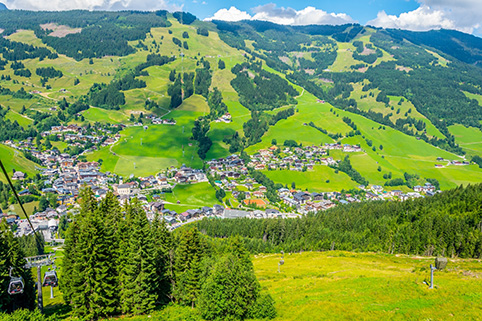
By using the Schattberg X press cabin lift to a height of 2014m. (6,610ft) a wonderful walk is possible for those who enjoy mountain walking, not in any way difficult, dangerous or unduly demanding.
Shattberg High level Circular Route
The 'Hohenrundweg' comprises a circuit around the west and middle peaks of the Schattberg, the mountain mass towering above Saalbach on the south side of the valley. Much of the route is along narrow paths reminiscent of British hill areas, but at more than 6,000ft above sea level. Generous waymarking makes losing the way very unlikely. The views include many of Austria's highest and most rugged mountains, in the Hohe Tauern, at about 12,000ft.
Start/car parking:
Large car park at the base station of the Schattberg cabin lift, by the side of the valley road at Saalbach. Free to users of the cabin lift.
WALK
After admiring the view and identifying the Grossglockner, Austria's highest peak, set off to the right from the top station. At the large sign board 'Hohenrundweg 2½ stunde' is the desired route. Descend a broad track to the col between the east (with cable lift) and west peaks of the mountain. To the left is a children's play area. Go through a wide gate and bear right at a signposted junction.
1. At the 2nd junction in 150m turn left; there is a 'Hoherundweg' sign. Go over a stile and follow a stony mountain path. Blue and yellow waymarks are generously provided. Alpenroses and bilberries are plentiful. Go over two more stiles and a little outcrop of rock, soon bearing right to descend. There is a little roadway on the left.
2. The path goes straight across the roadway; there is a 'Hoherundweg' sign. Above, to the right, are the buildings on the summit of the west peak. The delightful path continues. At a fork go right, to a stile and signpost is 40m. Go right again (a few metres to the left is a well-placed seat, with the peak of the Stemmerkogel 2,123m - 6,968ft beyond). There are now extensive views into the Glemm Valley.
3. Continue along the narrow path, now level. Join a rudimentary roadway by a little pond. Go straight across to a tiny, waymarked path opposite. At a junction in 150m turn left to descend quite steeply, with a snow fence on the left. The path soon levels, bearing right to continue the circuit. Pass under a ski lift and go through a gap in another fence. Fork left immediately to reach a signpost. Bear right for 'Hoherundweg'. At another sign in 60m go straight ahead, between extensive lengths of snow fencing. Hinterglemm is prominent in the valley below.
Descend past more snow fences, passing a few trees. Round the next bend is a sudden view of the east peak and the cable car station. The path now contours across a steep hillside. Join a roadway by a signpost, turning right to head for 'Schallberg Ost Berg Station', steadily uphill. Go through a gate to reach the outward route at the col, point 1. Turn left, uphill, to return to the cable car station.
Click here for further details about HPB Viehhofen; where 7 holiday units form the perfect retreat following a day's skiing or walking in an area of inspiring natural beauty.
Info
Karte
Details
|
Kondition
|
|
| Technik |


