| Schwierigkeit |
mittel
|
|
Aufstieg
|
239 hm |
|
Abstieg
|
239 hm |
| Tiefster Punkt | 925 m |
| Höchster Punkt | 1066 m |
|
Dauer
|
2:42 h |
|
Strecke
|
9,9 km |
HPB Viehhofen: Saalbach

Quelle/Autor: Holiday Property Bond Walks

Foto: Holiday Property Bond Walks, Holiday Property Bond Walks
Die Tour
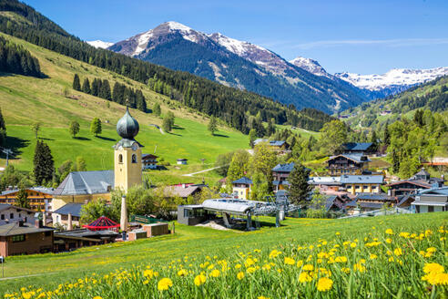
Saalbach is a lovely village, almost a small town, in the mid park of the Glemm Valley. Among the profuse hotels and guest houses are a few shops and the charming little square with fountain in front of the Gemeinedeamt.
SAALBACH & THE SUNSET PROMENADE
Although Saalbach is very much a winter sport village, there is a fair amount of summer activity.
This walk is an attractive circuit, initially on the 'Sonnseitpromenade' across the valley side, with the return by the riverside path. Some ascent but no difficulty.
WALK
Start past the bollards at the top of the car park. Turn right to head for the centre of Saalbach. Pass more bollards, cross the rushing stream and turn left, uphill at a road junction.Follow the main street, pass the little square, with fountain.
1.In a further 100m turn right; there are signs for 'Kohlmais Bahnen 200m'. The little road rises gently. Pass behind the church. Continue along the road through the outskirts of Saalbach, rising steadily. Pass a 'Ronachweg' sign on the right. At a fork keep left, for 'Sonneseit Promenade'. Reach the large youth guest house complex at Ronach.There is a right of way across the front of the buildings, to a 'Sonneseit Promenade' signpost.
2. Take an unsurfaced track at the far end, descending towards a farmstead, with fine views along the valley. Reach the Eder farm, turning right, downhill, at a signpost, along a tarmac roadway. At another signpost in 25m. continue down the road, round a large left bend, soon reaching a road junction, with a mountain stream on the far side.
3. Cross the stream on a bridge (for a shorter walk a right turn here leads directly to the valley road. Cross the road and the R. Saalbach to join the riverside track. Turn right to return to Saalbach.) Rise gently on a tarmac roadway towards Thurnerhof. There is another 'Sonnseit Promenade' sign. Pass to the right of the guest house complex. Go downhill; there is yet another Sonnseit Promenade sign in 20m. Go left at a junction to follow a gravel track across the valley side meadows, with occasional farm buildings. Continue along a grass track to a gate; join a farm roadway. Pass a large agricultural building on the left, a tiny stream and an open gate before reaching mixed woodland. At a fork go left to continue across the valley side. After a steep little descent, cross a stream and bear right, to a gate.
4. Go through a farmstead, descending to a junction in 60m. Turn left 'Sonnseit Promenade', to rise steadily past large detached houses. After passing a large farm building turn left, between that building and the last one in the group. In 25m. turn right to resume the route, along an unsurfaced roadway. Pass under a ski lift before joining the public road; the signs include 'Jausern'.
5. Turn right, downhill, passing the large Egger hotel. At a junction immediately below the hotel, turn left to descent and cross a stream. At the next junction, in a few metres, turn right to continue downhill, following 'Igelsbergerhof'. At a road junction with many signs bear right, along 'Iglsbergweg'. The road twists and turns as it continues to descend to Jausern hamlet by the side of the valley road, a cluster of guesthouses and pensions. Cross a bridge over a stream before reaching the valley road.
6. Cross the road, bearing left to a bridge over the R. Saalbach. At the sign 'Saalbach Promenade 1 stunde' turn right to follow the riverside track. Pass in front of the base station of a ski lift, bearing right. Stay with the track, ignoring bridges on the right; pass the little 'Fischerhutte' with its pond on the left. As the track divides keep right, close to the river. Pass the bridge over which the short route joins. Continue past the huge structure of the Schattberg X Press multi-storey car park before turning right to cross the river and return to the car park.
Info
Karte
Details
|
Kondition
|
|
| Technik |


