|
Aufstieg
|
365 hm |
|
Abstieg
|
951 hm |
| Tiefster Punkt | 2077 m |
| Höchster Punkt | 2996 m |
|
Dauer
|
3:20 h |
|
Strecke
|
10,0 km |
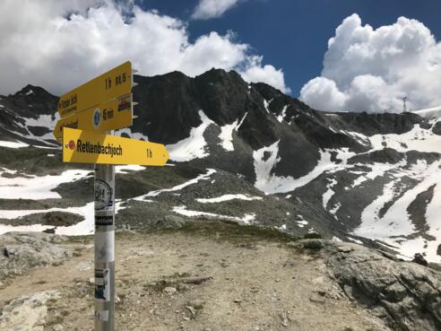
Walk to Sölden crossing the Rettenbachjoch

Foto: Minna Harshbarger, Macs Adventure
Die Tour
The most spectacular stage of the E5 route from Pitztal to Braunschweiger Hut, via Rettenbachjoch ridge and down to the valley station on the Rettenbach glacier in Sölden, catch the bus to Solden after your hike.
**AUG 2022 - Current the crossing is not possible unless you have the correct alpine equipment (crampons/ice axe) therefore please embark on the trail via Pitztaler Jöchl**
From Braunschweiger Hut to Rettenbachjoch: The initial climb towards the Rettenbachjoch also has a number of sections that are equipped with wire rope, but on the whole, this route is technically more straightforward than the alternative (via Pitztaler Jochl- see separate notes for this route).
The view from Rettenbachjoch is equally spectacular, stretching across to the built-up area around Rettenbachferner. The awe-inspiring views can be daunting even for seasoned skiers. The descent is rocky and crosses a number of boulders. Keep an eye out for the route markings. At the start of the season, there may still be too much snow to see the markings. If this is the case, follow the track across the snow at the edge of the piste and you may want to consider crampons/snow spikes for the descent. From mid/late July, you can also descend the Rettenbach glacier by cable car.
Both routes meet at the restaurant at the Rettenbach glacier valley station, where you can also find the road and bus stop for buses to Sölden.
Autorentipp
Check the trail condition and weather forecast at the Braunschweiger Hütte - From the Rettenbachferner valley station, take the bus to Sölden. The last bus leaves at approx. 15.30 hrs. Please inform yourself in advance about the departure times, and timetable information at https://fahrplan.vvt.at.
Info
Karte
Wegbeschreibung
Start
Braunschweiger Hut
Ziel
Rettenbach Glacier Mountain Restaurant
Weg
0.00 km - START from the Braunschweiger Hut. There are two options for today's hike: Via Rettenbachjoch (continue to follow the directions below for these options) or Pitztaler Jöchl (see separate notes for this option).
If you want to walk via Rettenbachjoch, head down the path bearing RIGHT at the yellow signs and follow the markings to Rettenbachjoch.
The route via Rettenbachjoch: Follow the red/white markings on the rocks. There is only one path. It is steep and equipped with ropes; use your hands if necessary.
1.60 km - Reach Rettenbachjoch, the highest point on today’s walk.
To start your descent, TURN LEFT in front of the house that is directly in front of you, coming from the summit. Continue to follow the red markings. The path is initially steep and rocky. A short section is equipped with wire ropes and takes you under the cable car and then left along the edge of the Karleskogel mountain.
2.70 km - You will see a path that leads down from Pitztaler Jöchl, this is where the paths converge.
3.10 km - Come to a road. Follow the road as it winds downwards. The large Rettenbach glacier mountain restaurant is clearly visible below. You can take a footpath to cut the corners.
3.90 - You have reached the Rettenbach glacier mountain restaurant. The bus stop for bus 8404 to Sölden is outside the glacier restaurant.
To continue to the Gaislachkogel middle station, cross the glacier road and follow the E5 markings through the Rettenbachtal valley. after approx. 1 hour in the Rettenbachtal valley, you will come across the glacier road again. Above the glacier road is the Rettenbachalm. From here you can take the bus as a shortcut.
Weitere Informationen
There are possibilities for refreshments at the following places:
Berghof Steinbock: https://www.berghof-steinbock.at/de/sommer/e5-wanderer
Gletschertisch Bedienungsrestaurant mit Café-Lounge: https://www.soelden.com/infrastructure-summer?do=info&id=5499
Opening hours can vary so we recommend always carrying enough food with you to keep you going!
From approx. the 30th of July, the “Schwarze Schneid” cable car runs from Rettenbachjoch down to the glacier, if you prefer not to descend on foot.
Ausrüstung
Always wear good walking boots with a robust sole, and take waterproofs with you. Don’t forget to take plenty of water with you (at least two litres) and to protect yourself against the sun. Trekking poles are recommended.
Sicherheitshinweise
Check the trail condition and weather forecast at the Braunschweiger Hütte as the descent can be difficult.
Today you may be walking past a few different areas where cows graze. Although generally very docile and used to walkers, keep your distance and never turn your back on a cow that is behaving strangely or aggressive. Be particularly vigilant around cows with calves.
If you’re feeling tired from the previous stages or have experienced problems with heights, do not attempt this stage – it is more challenging, both physically and technically than the previous stages!
Watch out for falling rocks and keep your distance from other walkers. At the start of the season, there may still be snow on this section of the route.
Always allow plenty of time for your hike. The walking times indicated do not include breaks. Rest and photo breaks must be added to the times indicated. Check the latest weather information and be on the lookout for changes in the weather. Storms can develop rapidly in the Alps. Do not leave the marked hiking trails.
