| Schwierigkeit |
mittel
|
|
Aufstieg
|
671 hm |
|
Abstieg
|
675 hm |
| Tiefster Punkt | 1922 m |
| Höchster Punkt | 2261 m |
|
Dauer
|
4:30 h |
|
Strecke
|
9,8 km |
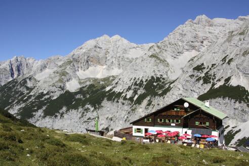
Walk on the Nordkette to Pfeishütte

Foto: Michael Kirchmayer, Michael Kirchmayer
Die Tour
An exhilarating hike on Innsbruck’s Nordkette mountain range to Pfeishütte Lodge and back.
You’ll take the Seegruben and Hafelekarbahn cable cars to Hafelekar mountain station 2,256m above sea level. From there, you’ll follow the Goetheweg trail and its promising views over the southern slopes of the Nordkette mountain range to Mühlkarscharte. At Mühlkarscharte, you’ll switch to the northern side of Nordkette and hike over Mandlscharte to Pfeishütte Lodge, where you’ll be greeted with some Tyrolean delicacies and stunning views.
Info
Karte
Details
|
Kondition
|
|
|
Erlebnis
|
|
|
Landschaft
|
|
| Technik |
Beste Jahreszeit
Wegbeschreibung
Start
Haferlekar Mountain Station (Innsbruck’s Nordkettenbahn cable car network 2,258m)
Ziel
Haferlekar Mountain Station (Innsbruck’s Nordkettenbahn cable car network 2,258m)
Weg
0.00km - TURN RIGHT as you leave the Hafelekar mountain station building (2,269m). A few metres up you’ll see a passage through a low wall leading to your RIGHT. This is where the Goetheweg trail begins. A signpost for Pfeisshütte Lodge will make it easier to get your bearings - stick to this trail and always follow STRAIGHT AHEAD. The Goetheweg trail is relatively flat, well-developed and runs along the southern slopes of Hafelekarspitze (2,334m) and Gleirschspitze (2,317m).
1.00km - After Gleirschköfeln (2,266m), the path descends a few metres to Gleirschjöchl (2,210m). Here, you can make a 30-minute detour to Gleirschspitze Mountain, if you wish. Continue STRAIGHT AHEAD on the southern slopes of Gleirschspitze to Mühlkarscharte (2,243m).
1.70km - There’s a short ascent to Mühlkarscharte. You’ll now switch to the northern side of Innsbruck’s Nordkette mountain range. The Goetheweg trail now leads over some rocky terrain and screes to the north towards the so-called Zugspitzblick. From this lookout point, in good weather you’ll be able to see Zugspitze mountain peak, as the name might suggest. Now our trail bends to the right and leads up the slopes of Mandlspitze (2,366m) to Mandlscharte.
3.00km - You’ll find yourself on Mandlscharte, the highest point of your hike today. To the north you’ll see Gleirschtaler Brandjoch (2,372m) and Mandlspitze to the south. Pfeishütte Lodge is now entirely downhill from here. You’ll descend into the wide basin via a number of sharp bends, always following the signs for Pfeishütte Lodge and ignoring any paths leading off to the sides. At first the terrain is barren and rocky, but the mountain pine trees become denser and greener the lower you descend.
4.90km - You will reach Pfeishütte Lodge.
4.90km - Take the same route back to Haferlekar mountain station.
The last cable car descent off the mountain is normally 16:30.
Weitere Informationen
Food and Drink
Hafelekarbahn cable car mountain station (2,269m)
Ausrüstung
Always wear good walking boots with a robust sole, and take waterproofs with you. Take plenty of water with you (min. 1 litre) and don’t forget sunscreen!
Sicherheitshinweise
Today you may be walking past a few different areas where cows graze. Although generally very docile and used to walkers, keep your distance and never turn your back on a cow that is behaving strangely or aggressive. Be particularly vigilant around cows with calves.
Always allow plenty of time for your hike. The walking times indicated do not include breaks. Breaks for photos and a rest need to be added to the specified times.
Make sure you find out about current weather conditions and keep an eye on weather changes. Thunderstorms can gather very quickly in the Alps.
Do not leave the designated hiking trails!
