| Schwierigkeit |
mittel
|
|
Aufstieg
|
1166 hm |
|
Abstieg
|
1167 hm |
| Tiefster Punkt | 1168 m |
| Höchster Punkt | 1846 m |
|
Dauer
|
6:55 h |
|
Strecke
|
17,3 km |
Loop walk from Längenfeld
Die Tour
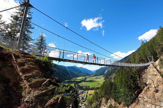
Challenge yourself with a steep climb to the Platter Grube and cross the spectacular suspension bridge between Brand and Burgstein.
Today’s route is a circular loop which offers great views of the Otztal. For the first part of this walk, you’ll ascend to the plateau between Brand and Burgstein. Pause to take in the fantastic panoramic views before crossing the suspension bridge, which hangs 200 metres above the ground. From here, the trail winds steeply back down and you’ll cross the valley to reach Huben and then follow the During-Höhenweg back to Längenfeld.
Info
Karte
Details
|
Kondition
|
|
|
Erlebnis
|
|
|
Landschaft
|
Beste Jahreszeit
Wegbeschreibung
Start
Bus stop Kirchplatz Längenfeld
Ziel
Längenfeld Church
Weg
0.0 km – Start at Längenfeld Kirchplatz bus stop. Cross the street towards the church and then TURN onto the narrow road to the LEFT of the church. Follow the street until it ends, from here a small path leads steeply uphill into the forest passing a power distribution box (signposted: Brandalm). Follow this trail uphill until it joins a wide forest path. Here, TURN RIGHT and follow the forest path to Brandalm.
1.5 km – From Brandalm, keep following the signs towards Hängebrücke (Suspension Bridge) /Burgstein.
3.3 km – At the Dorfstüberl Restaurant in Burgstein, TURN LEFT (signposted: Platter Grube)
3.9 km – At the turn-off for Gamskogel (signpost 189), continue STRAIGHT ON towards Platter Grube.
4.2 km – Follow the natural curve in the path across a stream; shortly afterwards, you will reach a small clearing. Near the entrance to this clearing, take the narrow path to the LEFT to climb steeply uphill to the hunting lodge.
5.7 km – The small hunting lodge is the highest point of today's walk. Follow the signs for Huben, first along a narrow path then later along a forest trail that winds its way downhill. Warning: From here, the route takes you very steeply down a narrow path. When wet, this section can be particularly slippery due to roots and stones.
9.5 km – When you reach the main road, TURN RIGHT onto the cycle path which runs parallel to the main road. Follow the signs for Huben and the red and white markings of the Ötztaler Urweg.
10.1 km – After the underpass, TURN LEFT and cross the bridge towards Huben. Continue STRAIGHT ON until you reach the fire station (“Feuerwehr”) bus stop. At the bus stop, TURN LEFT and then TURN LEFT again at the fire station. The fire station will remain on your left. Follow the signs for Pollesalm/Alpengasthof Feuerstein and the red and white markings of the Ötztaler Urweg. Pass above the campsite.
10.7 km – At the fork, continue STRAIGHT ON. (Do not follow the downhill path along the fence). You will soon reach a road. BEAR RIGHT on the road as you head downhill. (Ignore the path off towards the Feuersteinhütte).
11.1 km – At the bridge, cross the stream and TURN LEFT. Follow the signs for Astlehn and the red and white markings of the Ötztaler Urweg.
12.0 km – At FunPark, continue STRAIGHT ON. Follow the cycle path markings on the road and the signs for Panorama Duringweg. After around 1 km, cross the river and then immediately TURN LEFT.
13.8 km – At the bridge, cross the river and then TURN RIGHT. Follow the signs for Panorama Duringweg and the red and white markings of the Ötztaler Urweg.
14.1 km – When you reach the end of the wooden fence, TURN LEFT onto an uphill walking path.
14.6 km – When you reach the gravel road, continue to follow it uphill.
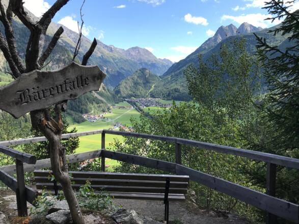
15.1 km – At the fork, TURN RIGHT onto a narrow walking path. Follow the signs for Längenfeld and the red and white markings of the Ötztaler Urweg. On the remainder of the route, you’ll pass the Bärenfalle (see photo) and Hoslach viewing points.
16.5 km – Before you reach the gravel road, TURN RIGHT onto a narrow path and continue to follow it downhill.
17.1 km – At the transmitter mast, TURN RIGHT onto a gravel road. Follow this road downhill. After a short time, TURN RIGHT onto a forest path. Follow this path downhill until you reach the gravel path along the riverbank.
17.8 km – At the river, TURN LEFT and cross the bridge at the electricity pylons. Then TURN RIGHT. Follow signs for Längenfeld. Ignoring the signs for Winklen.
18.0 km – Before the bridge at the AquaDome thermal spa (you’ll be able to see the outdoor slides), TURN LEFT onto a gravel road. Follow the red and white markings of the Ötztaler Urweg until you reach the main road.
18.6 km – When you reach the main road, TURN RIGHT onto the footpath next to the main road and walk towards the church.
18.8 km – You have reached your destination for today: the church in Längenfeld.
Weitere Informationen
Ausrüstung
We recommend wearing hiking boots that are well broken-in, plus a rain jacket and waterproof trousers in wet weather, as well as taking sun cream and a hat on nicer days.
In your information pack, you’ll find a detailed list of all the required hiking gear, including some good hiking boots, appropriate clothing, a rain jacket and a backpack
Sicherheitshinweise
The first part of this leg is spectacular but challenging, kicking off with a 700-metre ascent. You’ll cross a 200-metre-high suspension bridge, and you must be confident walking at heights and steady on your feet for the descent to the hunting lodge.


