|
Aufstieg
|
428 hm |
|
Abstieg
|
428 hm |
| Tiefster Punkt | 2842 m |
| Höchster Punkt | 3270 m |
|
Dauer
|
1:50 h |
|
Strecke
|
3,8 km |
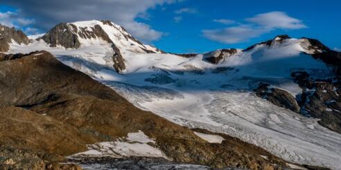
Bellavista Hütte - Summit

Foto: Minna Harshbarger, Macs Adventure
Die Tour
If you want to add on to your walk today, hike up for panoramic views of the region
Hike to the "Hintere Eis" for panoramic views of the region.
Info
Karte
Wegbeschreibung
Start
Bellavista Hut
Ziel
Bellavista Hut
Weg
Once you have arrived at the Bellavista Hut, the hike to the "Hintere Eis" can be a unique experience for reasonably experienced walkers.
The trail leads moderately steeply uphill over the block and scree slopes. The path is marked throughout with partly large stone markers and coloured spots. From the summit, there is a panoramic view. The ice stream of the Hintereisferner is just as impressive as the nearby Weißkugel, 3738 m, with its majestic summit.
The 360 summit view also has the shapely Finailspitze, 3514 m, opposite the Schwarze Wand, 3354 m, and the Grawand, 3251 m, with the top station of the cable car.
Weitere Informationen
Ausrüstung
Always wear good walking boots with a robust sole, and take waterproofs. Don’t forget to take plenty of water with you (at least two litres) and protect yourself against the sun. Trekking poles are recommended.
Sicherheitshinweise
Be careful, snow is not uncommon on the trail.
Always allow plenty of time for your hike. The walking times indicated do not include breaks. Rest and photo breaks must be added to the times indicated.
Check the latest weather information and be on the lookout for changes in the weather. Storms can develop rapidly in the Alps.
