| Schwierigkeit |
schwer
|
|
Aufstieg
|
817 hm |
|
Abstieg
|
255 hm |
| Tiefster Punkt | 942 m |
| Höchster Punkt | 1691 m |
|
Dauer
|
5:15 h |
|
Strecke
|
16,0 km |
Alternative Walk 1: Birgsau - Schofenpass - Warth
Die Tour
Alternative crossover from Oberstdorf to Lechtal, if the E5 route Kemptner Hütte - Mädeljoch - Holzgau is inaccessible.
Take a bus or taxi to Alpe Eschbach. The first 9km of the hike follows a paved mountain road into the tranquil Rappenseetal valley. From the Speicherhütte climb up an Alpine path with spectacular views up to the Schrofenpass. Via the Mansguber Alm you will arrive at the scattered houses of Lechleiten and then follow the Lechweg route (Lech River Trail) to Warth.
Info
Karte
Details
|
Kondition
|
|
|
Erlebnis
|
|
|
Landschaft
|
|
| Technik |
Wegbeschreibung
Start
Bus Stop Alpe Eschbach (942 m)
Ziel
Warth am Arlberg, Bus stop Steffisalpe
Weg
0.00 km - From the bus stop Alpe Eschbach follow the paved road towards Schwarze Hütte/Mindelheimer Hütte. Trail no. 441. The gently sloping road is a popular mountain bike trail. Be mindful of cyclists.
7.50 km - You will arrive at the Schwarze-Hütte. Continue STRAIGHT AHEAD and stay on the road (ignore the fork in hiking trail 441), pass the goods cable lift to the Mindelheimer Hütte and continue to follow the trail until you arrive at the Untere Biberalp. The trail will turn into a roadway. Now follow it more steeply uphill towards Speicherhütte.
10.40 km - After the Speicherhütte, the path will turn into a steep Alpine path. Continue STRAIGHT AHEAD following this path uphill.
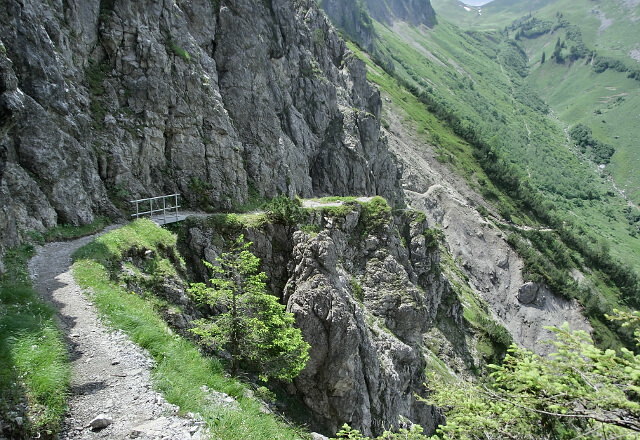
10.70 km - At the crossroads TURN LEFT and follow hiking trail 445 towards Schorfenpass. The path will now become Alpine and cross a steep slope, which drops steeply down on the valley side. The steep path is partially secured with wire ropes and bridges. This section requires a good head for heights and sure-footedness.
12.00 km - You will arrive at the 1690m high Schrofenpass, where your climbing efforts will be rewarded with a fantastic view of the Allgäu Alps and the Arlberg region. TURN RIGHT here and then follow the path 445 down the valley. Ignore all outward trails and continue through the pastures of the Mansgunter Alpe.
13.00 km - Continue STRAIGHT AHEAD on the path as it swings left. You will soon arrive at a road.
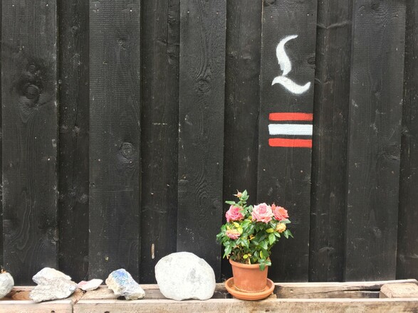
13.30 km - TURN RIGHT and follow the road. You will now be on the Lechweg (Lech River Trail) long distance path, which is well-marked with a curved L. Now keep following the Lechweg marked route. The Lechweg will lead you past the Hotel Warther Hof to the main road in Warth.
16.00 km - TURN RIGHT to reach the bus stop at Steffisalpe. Take a bus from here to Holzgau.
Anreise
Öffentliche Verkehrsmittel
Take Bus no. 7 from Oberstdorf bus station to Birgsau Alpe Eschbach:
https://www.mona-allgaeu.de/fileadmin/user_upload/Linien/SOA/Linie_07.pdf
Or take a taxi to Alpe Eschbach:
Taxi Office Oberstdorf: +49 8322 98210
Bus from Warth to Holzgau: Line 4268
Weitere Informationen
Refreshments can be picked up from Schwarze-Hut however, opening times can vary. Always carry enough food and water to see you through the day!
Ausrüstung
Always wear good walking boots with a robust sole, and take waterproofs with you. Don’t forget to take plenty of water with you (at least two litres per person) and to protect yourself against the sun. Trekking poles are highly recommended.
Sicherheitshinweise
This alternative route is not suitable for bad weather/thunderstorms.
The path over the Schofenpass also has an Alpine character and is partially exposed and covered by cable rope. A good head for heights and sure-footedness are necessary.
This is a popular mountain bike route. Be mindful of mountain bikers and make space if necessary.
You may be walking past a few different areas where cows graze. Although generally very docile and used to walkers, keep your distance and never turn your back on a cow that is behaving strangely or aggressive. Be particularly vigilant around cows with calves.
Always allow enough time for your hiking tour. The specified walking times only refer to actual time spent walking. Breaks for photos and a rest need to be added to the specified times.
Make sure you find out about current weather conditions and keep an eye on weather changes. Thunderstorms can gather very quickly in the Alps.
Do not leave the marked hiking trails!


